


HISTORY of KILLDEER ISLAND
Webster Lake
PROLOGUE
The history of the summer colonies around Webster Lake is either non-existent or buried in legend or newspaper articles. Most of the interesting facts have been lost as it was transmitted by word of mouth from generation to generation. This appears to be the case with the history of Killdeer Island. It has been nearly seventy years since the Island was opened to the public and the transformation of a wilderness into one of the prime locations on the Lake took place and yet the author was unable to find a single source where the story in its entirety could he found. Since the author witnessed the actual development itself, the knowledge accumulated over this period is being presented in this study so that some of the early history of Killdeer Island can be preserved.
Compiled from KILLDEER ISLAND AN EARLY HISTORY
Copyright © 1987
Bernard F. Duesel

THE EARLY HISTORY OF KILLDEER ISLAND
Killdeer Island derives its name from the numerous killdeer birds who inhabited the island and a few of which can still be seen there. The Island runs from the Narrows, the nearest point of land to the town, and the main road between Webster and Douglas, Route 16, about one mile distant. Originally the Indians had a trail the length of the Island over a small bridge at the Narrows which was the main trail between Boston and Hartford through Mendon. It was called an island because in the spring water filled the marshy area between the North Pond and Smith's Cove isolating it from the mainland. At a point across from Sandy Shore the water flowed into the lagoon next to what is now Indian Point and made a small island. In fact it was planned to erect a bridge across this narrow section making the western end an exclusive club. The State would not allow the change so the project died.
It is impossible to describe the shape of the Island in conventional, terms other than to say it is artistically irregular and devoid of any symmetry. On a map it looks like the midsection of a partially completed jigsaw puzzle with protuberances in all directions. It, is about a mile long and only about three hundred feet wide across from Sandy Shore to Middle Pond expanding to a maximum width of about a half mile measured from Nigger Hill on West Point Road to the tip of Craver Point. Killdeer Island is located at 420 3 North Latitude and 710 52' West Longitude at an elevation of 480' according to the United States Coast and Geodetic Survey.
It is on Lake CHARGOGGAGOGGMANCHAUGGAGOGGCHAUBUNAGUNGAMAUG in the town of Webster, Massachusetts about seventeen miles from Worcester. The topography is as irregular as its shape and although the terrain is not very rugged, there are few areas where a home could be erected without some grading to level the ground. In some areas there is a precipitous drop to the lake level while other plots gently slope towards the water but all too often with a sidewise incline to be leveled. It is this lack of symmetry that lends charm to what would otherwise be level symmetrical perfection to be found in many suburban developments. Most New England ponds are mud holes. Strangely enough many of the beaches surrounding Killdeer Island had white sand reminiscent on a smaller scale of those of Cape Cod and probably were formed at the same time by the same violent upheaval that formed the Cape.
Unlike the seashore beaches that are cleansed by the tides the Killdeer beaches depend on constant renewal by fresh sand which is carried into the water by the rainfall. Developments with their stone walls, cellar foundations and other impediments inhibit the flow of fresh sand, required for renewal. Coupled with the loss of sand by the wake of high speed motor boats it is likely that Killdeer's sandy beaches will soon be a relic of the past. Most of the subsurface is sandy but in some places stone and gravel predominate. In one instance a well was driven through a layer of seventy feet of clay and in another it was necessary to drill ninety-three feet to reach the rock formation for an artesian well.
The island is an ideal ecological laboratory for studying all phases of Nature's eco-system. It was no doubt formed by the glacial passage through the area and Nature has in every way repaired the damage and restored equilibrium to what must have been a catastrophe of the greatest magnitude. On the Island there are areas of wetland which purify the water and tall pine trees whose spreading roots hold the erosion of the sandy soil in check. The ground is covered by pine needles, woodland flora and shrubs that prevent, the soil nutrients from leaching out. It is little wonder that, wild birds and animals abound. It is claimed that before 1855 when Samuel Slater built the dam at East Village to impound water for his textile mill the level of the lake was four feet lower and at times there were several bodies of water. To this day there is evidence to support this as at times when the water level is low one may walk in, waist deep water from Union Point to a point just east, of Misery Island and from Wawela Park to Goat Island. Still visible are large swamps of cedar stumps which no doubt were inundated when the dam was built.
I first heard of Killdeer from my father, whose father George, was employed by the Slaters about 1880 and who told him of having been to parties on the Island. it was the custom for many Slater employees to visit the Island and for a small fee they could obtain permission to camp all summer. My grandfather had a boat which like those of many of the town natives was kept at the Pumping Station where he had a rectangular wooden box to lock up his oars and personal gear. Perhaps it was necessary to reach Killdeer Island by boat at that time although I know that scheduled service was later provided from Beacon Park to Point Breeze, Long Island, Killdeer, and even some of the smaller Islands on weekends in the summer. Bernard and Janet Malser have pictures of early Jumbo parties but I cannot identify my grandfather in any which precludes my using the story as fact but does not necessarily mean he was never there.
My first glimpse of Killdeer came in the summer of 1915 when I was a lad of eight and my dad and uncle took me to Beacon Park where we boarded Mr. Edgar Hill's Steamer, the stately Empire, and disembarked at Sandy Shore on Killdeer Island. Here an unpainted, weather-beaten, narrow row of stalls served the bathers as a place to undress. It was a summer day with. a deep blue sky and the not so gentle waves of clear sparkling water slapped the shore with an authoritative resounding splash. It was evidently a mid-week excursion trip as after walking but a few paces on the silvery hard packed sand we were alone on a wide expanse of beach about where the Killdeer Community Beach is now. I marvel that to this day, in spite of my youth at the time, the event stands out in my memory as one of the happiest days in my life. The vision is reinforced by the fact that while I was sitting in the water on the smooth sand an errant wave engulfed me, and I nearly drowned before my dad who was engrossed in conversation with his brother, realized my plight and came to my rescue not a moment too soon. In later years MY father often recalled the episode and told me how fortunate I had been on that day.
My next encounter with Killdeer came three years later, one which I should label not-so-close encounter. My cousin who was several years older than myself had a canoe which he kept at Beacon Park. We walked to the Park and paddled the canoe through the Narrows, past Misery Island into Middle Pond. Here we followed the south shore of Killdeer towards the strip of land now known as Indian Point. Little did I know we were passing the sandy beach on the shore opposite Sandy Shore where in 1923 we would build our summer home and where for the next sixty-four years I would spend my summers. Why did I not even take the trouble to glance at the beautiful oak tree that was near the shore and see how tall the three chestnut trees were in what was to be our front yard, since later they were only stumps when I saw them after the blight hit them and then they had to be removed.
I noticed there was a high ridge of land on Indian Point from which one could probably see all around Middle Pond. As we continued our paddling toward Goat Island we could see, off towards the Douglas woods, a large tract of straw color which my cousin said was Sugar Loaf Hill, probably a hay field where the hay was drying out. On Goat Island we noticed a windmill used to generate electricity. Would some power give us the gift to have a second chance, but retro vision is many years in the future so we had best enjoy the present.
The history of Killdeer prior to 1920 is practically nonexistent. In truth Killdeer Island appears to have been hallowed ground. No doubt it was originally occupied by the Pegan Indians who were a remnant of the Nipmuc. A plague is mentioned which practically wiped out the Nipmuc tribe so the Indian population around the Lake must have been very small. Historians mention a gathering of Nipmuc and Narragansett Indians in early times but this probably took place on the other side of the Lake where Roger Williams preached to the Indians.
The author remembers seeing the tall, stately Chief Payne Henries walking down Lake Street with a string of fish over his shoulder taking them to the village market. Payne was the son of Lemuel Henries, the last Nipmuc Chief who died in 1883. The Indians were privileged by law to sell fresh water fish. An old time resident told me her parents knew of natives who camped in the woods along with the Indians. There are still descendants of the Nipmucs living in the area.
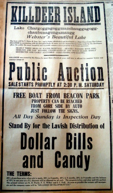
Killdeer might have originally been a part of Oxford as Dr. Frederick Brown in his history of Webster states, that when it was incorporated in 1832, Webster was formed from land taken from Dudley, Oxford, and South Gore. In 1812 when Samuel Slater started his mill East Village was called Oxford South Gore. Apparently Samuel Slater acquired the Roxbury Free School grant when he began his textile manufacturing in the early 1800s. Samuel Slater who owned the land on Killdeer Island gave permission for certain uses, such as a bath house on Sandy Shore, but the land was practically virgin until after World War I when his heirs sold it to the Killdeer Development Company owned by Kelsey Purdy, a developer from Schenectady and Frank Wilber, a Webster real estate man. A 1920 survey shows there were about a dozen buildings on the Island along with the bath house and a small camp, the Jumbo, erected in 1866 on what is now South Shore Road facing Point Breeze.
In the Slater years there was a gate of horizontal wooden crossbars which had a hole in each through which a chain passed and a padlock secured the entrance to the Island near the Gore Road. It was necessary to obtain a pass from the Slater Company to enter. On special occasions the gate was opened to carriages. One of these special events was the horse racing which took place around the circle now called Lake Circle.
The Slater's were engaged in international commerce and entertained many foreign dignitaries, but this was at the Horton Mansion which was located on the Lake near East Village. There was a small ice barn on the Island with saw dust and the usual accessories and this was located at the intersection of Killdeer Road and South Shore Road directly behind the location of the first store. At the site of the first store there was originally a small structure which rented horses and gave pony rides for children.
Jumbo was occupied by one of Purdy's favorite superintendents, Tom Waddington. There was also a baseball diamond near what is now the Killdeer Island Club House. As far as the Development Company was concerned, Killdeer began at the square pillar about three hundred fifty feet from where Cross Court rejoins Killdeer Road. Maps of the Lake include the area from the marker, to the Gore Road as being part of Killdeer Island. Some of this land to the south was owned by Mr. Ernest Wallis who had a picnic grove and while this land was to be highly developed later as Indian Ranch, the present survey deals mainly with the 1920-1930 decade. The author has no knowledge of the north shore property near the Gore Road.
In the early twenties the new owners actively promoted the development of the island. They engaged the services of Sperry and Buell of Bristol, Connecticut, who surveyed the land and divided it into plots. A brochure describing the Island entitled "Beside Blue Water" was published and the property widely advertised as the Jewel of Worcester County. It certainly was a paradise for nature lovers. Having been held by the Slaters for so many years random development was inhibited and now the new owners envisioned a planned community with restrictions that would preserve much of the natural beauty. It was an idyllic spot with all varieties of stately trees and native shrubbery such as mountain laurel.
Killdeer Island
Mr. Purdy built a beautiful summer home on Beacon Road on a bluff overlooking Middle Pond. At that time the entrance to Beacon Road was through a deep narrow cut that looked like a tunnel. On his waterfront was a large majestic oak tree which appeared on many picture post cards of the Lake and which is still standing at the present time. Across the street was a stable where his daughter Ruth kept her horse. Adjacent to his home on the east side was a large sand pit which renewed his bathing beach with white silvery sand after every rainfall. Mr. Purdy loved nature and the outdoors. He also liked plenty of fresh air and his large screened porch facing the lake had panels reaching to the floor to allow the air to enter. The house was painted white with yellow trim and fit right into the landscape. He enjoyed the native trees and shrubbery and left most of them, especially along the shore, just as he found them. Left to its own design nature has a way of maintaining its own ecological balance. Decaying trees and vegetation renew the soil and occasional ground fires started by lightning clear out the underbrush for new growth. However I do not see any harm in helping nature along a bit since we don't all have 100 years to wait for nature's time cycle.
Disregarding the philosophies and returning to Mr. Purdy's house, I remember his front porch had a screen door on the East side which led to an open porch with a pump. This was the side facing our house and being his next door neighbor I often observed him pumping the clear cold water which was not much different from the spring fed Lake water. Many people would take their Saturday night bath in the Lake which had a full Winter to renew its purity since practically all were summer residents. There were no clothes washers, dishwashers, or other facilities we take for granted today.
Next to the Purdy's, to the west, was a large plot later to be built on by his niece, the Hahns of Providence. Still further west was a small summer camp built by Sam Healy who worked in the Post Office. Next to Sam's was a substantial residence built by a Webster merchant, Alexander Racicot who became an early member of the Board of Directors of the Club. On the lot across the street the Racicots had a five car garage at the back of the property with a tennis court in front. A large boat house with a massive concrete base projected from the waterfront. Continuing along the Beacon Road waterfront were the homes of Waterhouse, Creamer, and Haggerty. It was a cosmopolitan group from Providence, Hartford, Auburn, Oxford, and Worcester who joined the natives for the summer. To the East of Mr. Purdy's was the long narrow strip of land, some seven hundred feet long, which is now Indian Point. A Webster dentist, Dr. Westphal purchased this land, and also owned the sandy beach next to Mr. Purdy, which was used as a private bathing beach. Access to Indian Point could only be by a narrow strip of land along the shore as there was a marsh alongside the lagoon already mentioned, which was usually under water. Mr. Frank Todd, a Webster barber purchased this lot which has now been filled in to provide direct access to Indian Point.
In 1920 Indian Point or Sea Scout Point as it was called was not as heavily wooded as it is at present. It was much narrower with a high mound near the center, before it was leveled and the marsh filled in to make it wider. It was called Sea Scout Point because the Sea Scouts had a boat house on the point with a high observation platform from which they could view the sailboat races. Many sailboats were moored in the shoal between the tip of Indian Point and the South Shore mainland. Later the sailboats moved across the Lake to the marsh behind Winter Cove. The shores of Indian Point were continually being eroded and the owner, Dr Westphal, spent his summers hauling rocks in a large work boat he owned from across the Lake, to bolster the receding shoreline. Later pines were planted along the west shoreline and now are over sixty feet tall so erosion is no longer a problem.
Misery Island had a much higher craggy peak in the twenties, but campers leveled the top so as to gain more camping space. The landmark windswept pine still stands sentinel guarding the west shore of Killdeer. There is a long narrow strip of land which is often under water connected to the northwest end of the island . This isolated island in the Spring serves as a rookery where numerous baby ducks can be seen. I am of the opinion that before Samuel Slater raised the level of the Lake in 1855 that Misery Island was connected to the mainland and a part of Killdeer Island. It is very shallow between the island and the shore and motorboats cannot use this passage with safety.
The land area next to the Narrows was quickly developed and became known as French Point since many of the settlers there were of Canadian descent. Actually the correct name as given on the official Killdeer map was Lake Circle. Mr. Cazeault who owned a lumber yard and roofing business, built himself a large house and at least twelve small cottages for summer rentals. Some of these were on the road across from the Killdeer Beach and all have now been converted to year round homes. West of Mr. Caseault new homes were erected by two sisters who each had her own house, Marie and Eva Gagnon. Nearby Jean Henault, the Zumphys and Dandurands also were on Lake Circle. Simultaneously, with the building activity at Lake Circle, other areas of the Island were being built upon. Joseph Patenaude had a summer home on the bluff just east of Mr. Cazeault's.
The area of West Point Road became known as Germantown, although many were not of that extraction. Mr. Elmer Doe, a builder from Worcester and Mr. Edward Pitfield, also a builder from Worcester, put up houses near the west entrance to West Point Road. Mr. Pitfield became one of the early club directors. At the site where Nigger Hill was located, the Canavans built their home. Further east, on the North Pond side, of the Lake the Neuliebs, Schremsers, and Shaeffers were early pioneer builders. The Benoits built Camp Belvedere on Killdeer Road near Cross Court, and the Gablers had a hide-a-way which was practically obscured by trees next to the Community Club. Mr. Brouillette, a carpenter, built his home at the intersection of Killdeer Road, and Sandy Cove Road. Mrs. Cobb lived on the waterfront across the street.
Further west on the North Pond shore were Fred Lavalle of Worcester with Camp Sit and Sippit, along with the Casaubons of Webster. On the South Shore on the bluff facing Point Breeze, the Klebarts, Jacobs, Selligs, and Salisburys joined the Jumbo as neighbor.
In 1923 Frank and Malvina Duesel, the author's parents, built a six room cottage on the shore next to what has been called a sand pit adjoining the Purdy house. The cottage was white with green trim and there was a matching garage up near Beacon Road. Although the author was present during the early days of the development, he was essentially a summer resident and apologizes for not being able to list many whom I'm certain were pioneers.
The first merchants on the Island were entrepreneurs who erected a small shed at the side of the road near the present entrance to Indian Point. They were the David brothers and sold soda, ice cream, bread, milk, and hot dogs. They claimed they were operating on State land, and could not be legally evicted. There was only one legal commercial parcel of property and that was at the west intersection of Killdeer Road, and South Shore Road. Here a small convenience store with a circular drive and gasoline pump was erected and run by Mr. Charles Toutant. Later the gasoline pump was removed and the store taken over by Mr. John Faber.
The store was subsequently purchased by Mr. Cotsidas who took down the building and kept the property vacant. Prior to the rapid development of the Island in the early twenties there were a few tent dwellers in the summer and among these were three teens aged boys, Leo Racicot, Charles Clairmont, and Romeo Bernier, who camped on a high spot of ground overlooking Misery Island. In order to go to town the boys had to place their clothing on their heads and wade across the narrows. In the early twenties, the Killdeer Development Company had a Cadillac Jitney which would meet prospective buyers at the station and bring them out to see the property. A colored post card showing the Club House was used to promote sales of lots. One of these depicts the Club House as being on the waterfront but no one can recall that it was ever but in the present location. The clubhouse had a piano, pool table, and games for the children, as well as a full time attendant, Mrs. Clark, who was provided with a house in the West Point Road section.
It is rumored that Mrs. Clark carried an umbrella as protection against skunks she encountered on her way home at night.
Saturday nights an Orchestra played for dancing on the large outdoor circular dance floor, reputed to be the first outdoor dance floor in the East. Erected adjacent to the Club, it had a tall Maypole in the center, with strings of colored lights leading to the top. The Ideal Orchestra with Harry Piehler at the piano, and Red Evans at the saxophone, did not like mosquitoes, so an outdoor screened cage was provided.
Among the favorite renditions were "I'm Going to Bring a Watermelon to My Girl Tonight", "The Melody That Made You Mine" and "Show Me The Way To Go Home" which they played promptly at 11:45 P.M. to comply with the Blue Laws prevalent at the time. The dance was for members and guests, but all the town teenagers came to enjoy the fun and they were welcome. The sale of property was assisted by radio station WKBE, which went on the air in 1925. The ten watt station was constructed by a local resident, Alfred Kleindienst, and featured a program where a listener could call in and they would serenade the caller with a song. I can remember my mother listening while they sang, "How do you do, Mrs. Duesel, how do you do, sitting in your cottage on Killdeer".
Around 1930, Dr. Westphal sold Indian Point and squeezed a large dwelling in the lot between the Purdy's and Duesel's. Mr. Purdy had passed away, and his wife had sold the house to the Sjogrens of Auburn. The Sjogrens restored the house to its original beauty and had an artesian well driven which they shared with the neighbors before the advent of town water. There can be no doubt that the post-war boom contributed to the rapid growth of the community. A post card sold at the local stores, had a picture of some waterfront homes on Killdeer proclaiming there were now 96 homes on the Island. But the depression of the thirties took it's toll and the growth slowed to a snail's pace. By 1930, the initial phase of the development was over, with most of the desirable lots having been sold. After Mr. Purdy's death, the Killdeer Development Company took less interest in the management of the Club's affairs, so in 1930 the Killdeer Island Club was incorporated to manage future development.
Some of the ideas incorporated into the by-laws would today be unconstitutional, such as giving the Board of Directors the right to purchase any property offered for sale if they did not approve of the prospective purchaser. This provision was later repealed.
1930 OFFICERS KILLDEER ISLAND CLUB
President William Dick Sr.
Vice President Edward F. Pitfield
Treasurer Charles H. Turner
Clerk William Dick II
DIRECTORS
William Dick Sr.
William Dick II
Edward F. Pitfield
Calvin S. Wheeler
Charles H. Turner
Alexander N. Racicot
Herman A. Neulieb
At a special meeting of The Killdeer Island Club held September 2, 1950,
the following were elected as active members of the corporation:
ACTIVE MEMBERS
- Fred C. Brouillette
- Arthur Cazeault
- Lewis E. Coates
- Fred Hahn
- Alice N. Harris
- Paul Neulieb
- Arthur F. Raymond
- Ruppert. W. Robinson
- Harold Shaw
- William Schur
- George L. Thompson
- A. H. Witt
- Arthur Kelland
- Andrew McIntosh
- C. A. Paradis
- Albert Remie
- Earnest L. Wallace
- Gertrude Upham
- William Sellig
- Howard W. Loring
- Clarence Dupre
- Burt H Tourtellote
- Arthur H. Klebart
- Gordon F. Doe
- Floyd W. Moyers
- Mary J. Parsons
- Edward Wheeler
- Albert Miller
- E. Peletier
- Joseph Jacobs
- Louis Schremser
- Ludge Alix
- Samuel Healy
- Edward Salisbury
- Richard Canavan
- W. W. Averill
ASSOCIATE MEMBERS(aka The Women of Killdeer)
- Genevieve Coates
- Annie S. Salisbury
- Grace C. Hahn
- Amelia R. Canavan
- Anna A. Racicot
- Anna Q. Miller
- Rachel Shaw
- Mary E. Thompson
- Josephine Jacobs
- Adele Schur
- Edith T. McIntosh
- Alice Witt
- Lora H. Broulliette
- Bertha C. Neulieb
- Blanch Paradis
- Edith Kelland
- Helen D. Dupre
- Rose Sellig
- Cornelia S. Pitfield
- Marian Alix
- Ida Dick
- Marian G. Dick
- Lena Schremser
- Ruth G. Loring
- Anna J. Neulieb
- Alice E. Klebart
- Cecil M. Turner
EPILOGUE
Killdeer Island is still a beautiful spot. The transition from a Summer Colony to one of year-round homes has replaced the rustic beauty with man-made beauty in keeping with the life style of the present generation. In place of the narrow winding dirt roads there are paved roads even on the side streets and there are well kept green lawns, nursery bought shrubs, and cultivated flowers. The new homes are in the style of suburbia and those being modernized follow the same pattern . The Purdy residence remains on Beacon Road, but other than the landmark Oak still standing on the waterfront there is little that bears resemblance to the original structure. Pine needles that kill the grass, and tall pines that block out the rays of the winter sun are not desirable for year round living, so the trees on the west side were removed to make space for a flower garden. On the rear lot, where the stable once stood the trees, have been taken down to build a three car garage and storage loft.
The residence was converted to a permanent home by the Sjogren's granddaughter Eleanor Hallock who lives there at present. The dwelling erected by Dr. Westphal next to Purdy's changed ownership a number of times, with each owner making additions and embellishments so that the original is no longer discernable. It is now the attractive home of Rose and Abraham Blackman. The cottage to the east of Blackman's as stated was built in 1923 by my parents. It is now occupied summers by the author and his wife Mary. The house is exactly the way it was then and the surrounding area extending back to the Killdeer Road is heavily wooded with a variety of trees and native shrubs. Many wild plants such as Lady Slippers and Jack-In-The-Pulpits still thrive in the back woods.
To the West of Hallock's, the former Hahn residence has been modernized along with Sam Healy's camp which is now the guest house of the new owner, James D'Alessandro.
Lake Circle, or Cazeault Point, (as it was once known) was devastated by a 1938 hurricane and the cottages have been rebuilt or altered for private homes that can no longer be recognized as the rentals. One remaining, although converted to a permanent home, is on Killdeer Road opposite Sandy Shore and occupied by an old time resident Eva Munsch. Another landmark that remains in its original state is across the street from Eva's and is the Phillip Nims camp. Evelyn Nims served as Secretary of the Killdeer Club for many years in the pioneer period.
Further down the road, at the intersection of Beacon and Killdeer Roads the original summer residence of the Ralphaelson's still stands and is owned by the son Howard.
The 1938 hurricane also raised havoc with a group of rental cottages near the entrance to South Shore Road bordering on the Indian Point lagoon. Some of these cottages owned by Arthur Raymond were completely demolished and had to be rebuilt. Today they are all privately owned, well kept and little changed in appearance from the original. On South Shore Road there are a number of camps intact from the early 20's, and the camp built by Arthur and Alice Klebart on a bluff overlooking Point Breeze comes to mind. It is now owned by their son Rodney and is typical of the first camps erected.
The Jumbo was acquired by Leonard and Janet Malser a few years ago, and moved to a back lot across the street. It was reputedly built in 1866 as the sign over the entrance still proclaims but the name Jumbo belies its size because before many additions were made it was small. Leonard and Janet built a year round home on the site of the Jumbo. Craver Point which protrudes into Smith Cove from the South Shore Road has been a landmark on the Lake for many years. The dwelling as viewed from the water appears to be the original.
The Killdeer Clubhouse which had also served as the office of the Developers was demolished in recent years, and replaced by a concrete block structure that serves the community well as a meeting place for business and social activities. Unfortunately many of the surrounding pines, which were nearly one-hundred years old, had to be removed. The gully between the road and the clubhouse was filled in by Henry Racicot, the son of a pioneer resident, Alexander Racicot. There is now a circular drive into the clubhouse and it is a fine asset to the Island.
Once again it must be stated that it is impossible to mention all who took an active roll in the early development but the author would be remiss if a few people intimately bound with Killdeer lore were omitted. One was Jim Mr. Purdy's handy-man, whose main duty was taking care of Mr. Purdy's daughter Ruth's horse, Beauty. Mentioning of Beauty's name brings to mind an episode that occurred in this time period when Ruth, an accomplished equestrian, rode Beauty to the waterfront down the gentle slope which has been referred to as a sand pit to drink the water. Beauty leaned over a bit too far and Ruth took an unexpected bath. Fortunately she suffered no injury except to her pride.
Once again the author must ask the reader's indulgence as extraneous material has been introduced which has no place in a scientific treatise. Returning to some earlier inhabitants, Mr. Harry Marcoux is remembered as being a man of many hats. Harry could perform any type of operation from making cement blocks to felling large trees. He operated in the hollow just to the East of the Sandy Cove Road entrance into Killdeer Road. Although his deed prohibited him from engaging in manufacturing no one ever challenged him or felt it a threat to their business.
Across the street Mrs. Cobb had a large garden where she raised vegetables. She once sold native corn for twenty-five cents per dozen and she was a welcome neighbor. George Schremser had a year round dwelling at the West intersection of Beacon Road and Killdeer Road, and did small contracting projects on the Island. After the season ended, and the city slickers departed, the natives resumed their social life for the Winter, and George often played cards with the Purdy's before they left for Florida. The advent of paved roads and town water in 1966 helped accelerate the transition to year round residences.
Originally the entrance road meandered like a serpent to avoid grading expenses, and in some instances to take advantage of certain water front locations. Close to the Gore Road (now Route 16) the narrow dirt road made a hairpin turn around a small hillock almost reversing direction before it continued ahead. This was probably following the original trail which had to stay on high ground to avoid the marsh through whichit passed. To this day there is a right angle turn near the Indian Ranch border on Killdeer Road and this helps preserve the natural beauty by slowing traffic and not making a racetrack of the main road. The completion of Route 395 from New London to Worcester hastened the day when this community will be one of year round homes. This day only awaits the arrival of town sewers which are already being planned in the near future. Some equate growth as being synonymous with progress but those of us who were fortunate enough to enjoy the pristine beauty of this paradise in its early days, can only look back on a vanishing landmark as the trees continue to fall, the water becomes more congested and the open space is less and less each year.
CAMP ON KILLDEER ISLAND.
THE NARROWS
Old photograph showing the steamboat Empire on which the author made his
first trip to Killdeer Island. Just to the rear of the Empire is the
flagship The City of Webster passing Killdeer Island and Misery Island
to the left on its way to Point Breeze. The fleet of vessels owned by
Edgar S. Hill, a local lawyer, consisted of five boats-- the Leslie,
Vixen, and Point Breeze in addition to the two already mentioned, They
began operating about 1902.
BEACON PARK
Pre 1920 photograph of Beacon Park from which the author embarked on the
steamboat Empire on his first visit to Killdeer Island. The trolley car
ran from downtown to Beacon Park and the boats departed from the dock
where the City of Webster is moored in the picture. My cousin's canoe
in which we paddled by the South shore of Killdeer was stored on a rack
in the large building to the right of the City of Webster and was operated
by Ralph Hill the son of Edgar Hill In the winter the canoes were all
chained together to prevent theft.
Photo post card looking out over Middle Pond from Purdy house with oak tree in foreground. Indian Point is at left with Long Island and Point Breeze in the distance. Circa 1925
1920 post card showing old Club House on waterfront
Photo post card of Beacon Road waterfront. Purdy house is behind canoe in foreground while author's. cottage is obscured by trees at far right. Circa 1930
ACKNOWLEDGMENTS
The author is indebted to many people for their assistance in preparing this Early History of Killdeer Island and without whose help it would not have been possible to preserve much of the material for posterity.
First, I must thank my wife Mary who although not a native spent many summers on the Island with our children and was able to corroborate many of the events narrated by my parents which my failing memory needed.
Next I am indebted to my son Bernard Jr. who proofread the text and corrected my many errors. Matt Chabot, a life long native of Webster as well as a long time friend, provided the photographs for the illustrations as well helping me recall certain past events. He thought the vehicle used by the Killdeer Development Company to transport people to see the property was a Pierce Arrow, while I thought it was a Cadillac.
The confusion trying to recall the make of vehicle may lie in the fact that it might have been a standard chassis with a special body made by a company famous for making custom bodies, Waterhouse-Webster. Since Mr. Waterhouse had purchased property from the Killdeer Company, they may have reciprocated and arranged to have a special body built on a standard chassis. It is known that they built bodies on Pierce Arrow chassis and such a vehicle would boost Webster and attract the attention of buyers. This is pure conjecture.
Continuing my acknowledgments after my usual digressions which persist to the end I must thank Lynn McLauglin, who has a large collection of old post cards from many sources and which served to refresh my memory. Leonard and Janet Malser have pictures of early Killdeer parties which they found in the Jumbo. They reviewed an early text and made suggestions. The largest source of information is to be found in past issues of The Webster Times which has accurately reported local events for many years. The old copies of the Times have been microfilmed, and while the Corbin Library has microfilms of all editions their viewer has been out of order for the past year and it was necessary to view them at the Nichols College Library, for which the author is grateful.
Stanley, the Town Of Webster Engineer made available old maps of Killdeer Island none of which provided any information, not on the Sperry Buell 1920 Survey. Elmira Surozenski, the present Secretary of the Killdeer Island Club, made a membership list of charter members in 1930 available.
VALLEY OF THE NIPMUCKS
The Great Trail
Compiled by Marion H. Norton
The so-called Great Trail of the Indians extended from what is now Boston to Hartford on the Connecticut River. This was assuredly a much used Indian Trail when the white men settled on the Massachusetts shores. The Trail was direct and skillfully laid out, not alone for traveling, but for hunting, fishing and shelter. Three places, notable in Indian life, were controls for the trail that was to become the Connecticut Path: There were the salt-water inlets and beaches of the Boston bay, the central freshwater lake at Webster, and the falls and long rapids on the Connecticut River at Windsor.
Midway between Boston Bay and the Windsor Rapids was Chaubunagungamaug, known today as Lake Chargoggagoggmanchaugagoggchaubunagungamaugg. It was a Lake of the Great Spirit in Indian mythology. Early records indicate that, before the coming of the colonists, the lake was an intertribal preserve. Apparently there were no Indian villages situated on the Lake until the establishment of "Chabanakongkomun," one of the Reverend John Eliot's praying towns, in 1672.
The northern Narrows was the Indian trail crossing. There, a short and easy fordway and a low-lying peninsula (Killdeer) facilitated the crossing to or from the Douglas Forest. In later years, the paths of the pioneers crossed at that Narrows before roads were laid out around the lake. The distance around the lake is about 16-miles.' One of the earliest maps of the Trail was prepared by Woodward and Saffery in 1642. It shows the Trail crossing over the lake at Webster, Mass., as previously described.
In 1660, this route still played an important part in such trunk-line arteries as the Bay Path to Springfield, and the path to Norwich and New London. But with the settlement of Woodstock in 1686 and the coming of the Hugenots to Oxford in 1688, the crossing assumed less and less importance. By 1718, when a territorial survey was made, the crossing was considered of no significance.
There is an ancient plan in the Massachusetts Archives which shows 240 acres lying north of "Chabanaguncamogue pond." Undoubtedly this was the land where Eliot had established his praying town of Chaubunagungamaug and where, subsequently, the Indian constable, Black James, lived. The plan, containing .a survey
Footnote 1: Until the 1920's, Killdeer was called, and for practical purposes was, an island. Access was over a small wooden bridge over a swampy creek, which was later filled in. Visitors at that time had used the lake steamer or boats to get to the beautiful, sandy beach, or youngsters would swim across the Narrows. Today, Killdeer is a highly residential section, chiefly of all-year homes, but evidence of early recreation remains in the sandy beach (privately owned), Smith's Cove (considered the deepest part of the lake) and a circular road, where horse-races were run in the 1800's. dated October 23, 1700, was presented in petition to the General Court. The petition, initiated by Timothy Dwight of Dedham, asked that he or his son, Josiah Dwight of Woodstock, be assigned certain of these acres for the purpose of providing, food and shelter for the mother of Black James.
An old fort is shown in the center of the plan. Indications are that, after King Philips War (1675 ), forts were built by the praying Indians who still enjoyed the indulgence of the white settlers. The only evidence of the old fort is a flat-topped hill above Cranston Print Works. This area is scheduled for excavation to make way for the continuance of Route 52. Conceivably some artifacts may be turned up, confirming the existence of the old fort at this site.
No official record of any Indian name for the lake or trail has been noted prior to 1668. At that time a treaty was signed with the Nipmuck clans and the Chaubunagungamaug clan was a party to the signing. The name in the treaty reads: Chaubunakongkomuk. Because there were no white settlements in the midland country until 1686, this -lack of an official or historical record carrying the name is understandable.
Footnote 2: Evidence of the Indian Reservation (see map) lay in a cemetery and huts, which were bought in 1887 by Honorable Charles Haggerty and deeded to the town to be preserved. Something went awry with these plans. No one seems to know. A few remaining Indian families were moved to houses on Lake Street. For years, children played in the "Indian Woods" on George Street and, on several occasions, discovered Indian artifacts. When, ten years ago, town officials sought to make a playground there, it was found that the land had been, in error or ignorance, deeded to a private family. Only two years ago, part of this land was recovered by the town and will become a playground.
Cover 1918 photo of Killdeer Island from The Narrows. Courtesy of Matt Chabot.
Prologue
Pages 1-9 Early history of Killdeer Island with emphasis on the period 1920 - 1930.
Pages 10-12 Epilogue. A view of the few remaining mementos of the past.
Page 13 .. Pre -– 1920 photo showing Misery Island, part of Killdeer and the steamer Empire as viewed from The Narrows. Courtesy of Matt Chabot.
Page 14 Photo of Beacon Park about 191 showing dock from which author departed on his first visit to Killdeer. Courtesy of Matt Chabot.
Page 15 Post card photo looking over Middle Pond from the Purdy house with oak tree in foreground. Circa 1925
Page 16 ,1920 Post Card showing old Killdeer Club. Courtesy of Killdeer Development Company.
Page 17 Post card photo of Beacon Head waterfront. Circa 1930
Page 18 Bibliography
Page 19 Acknowledgements ADOODUM
SCHEDULE OF MAPS
I. Map of Webster Lake. Circa 1920
II. Map of Killdeer Island 1920
III. Survey Map. Western half Killdeer Island. Courtesy of Killdeer Development Company
1V. Survey Map. Eastern half of Killdeer Island.
Courtesy of Killdeer Development Company
Note: The above two maps are not included in ail editions
KILLDEER ISLAND AN EARLY HISTORY
Copyright © 1987
Bernard F. Duesel
Dedicated to the memory of my mother who always said that one day she would own a piece of Samuel Slater land and made it come true on Killdeer Island.
GOSHEN, NEW YORK
OCTOBER 1987